


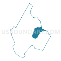
Voting District 11, Avery County, North Carolina
About
Outline

Summary
| Unique Area Identifier | 639320 |
| Name | Voting District 11 |
| County | Avery County |
| State | North Carolina |
| Area (square miles) | 16.42 |
| Land Area (square miles) | 16.36 |
| Water Area (square miles) | 0.05 |
| % of Land Area | 99.67 |
| % of Water Area | 0.33 |
| Latitude of the Internal Point | 36.10213800 |
| Longtitude of the Internal Point | -81.84117550 |
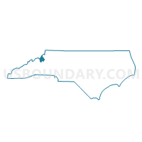
Maps

Graphs
Select a template below for downloading or customizing gragh for Voting District 11, Avery County, North Carolina


Neighbors
Neighoring Voting District (by Name) Neighboring Voting District on the Map
- Voting District 02, Avery County, NC
- Voting District 04, Avery County, NC
- Voting District 13, Avery County, NC
- Voting District 16, Avery County, NC
- Voting District 19, Watauga County, NC
- Voting District PR07, Caldwell County, NC
Top 10 Neighboring County Subdivision (by Population) Neighboring County Subdivision on the Map
- Watauga township, Watauga County, NC (3,558)
- Banner Elk township, Avery County, NC (2,996)
- Pineola township, Avery County, NC (1,207)
- Montezuma township, Avery County, NC (676)
- Linville township, Avery County, NC (453)
- Globe township, Caldwell County, NC (385)
- Carey's Flat township, Avery County, NC (132)
Top 10 Neighboring Place (by Population) Neighboring Place on the Map
Top 10 Neighboring Unified School District (by Population) Neighboring Unified School District on the Map
- Caldwell County Schools, NC (83,029)
- Watauga County Schools, NC (51,079)
- Avery County Schools, NC (17,797)
Top 10 Neighboring State Legislative District Lower Chamber (by Population) Neighboring State Legislative District Lower Chamber on the Map
Top 10 Neighboring State Legislative District Upper Chamber (by Population) Neighboring State Legislative District Upper Chamber on the Map
- State Senate District 45, NC (184,898)
- State Senate District 44, NC (173,941)
- State Senate District 47, NC (168,288)
Top 10 Neighboring 111th Congressional District (by Population) Neighboring 111th Congressional District on the Map
Top 10 Neighboring Census Tract (by Population) Neighboring Census Tract on the Map
- Census Tract 9209, Watauga County, NC (4,404)
- Census Tract 9301, Avery County, NC (3,100)
- Census Tract 310, Caldwell County, NC (3,042)
- Census Tract 9302, Avery County, NC (2,723)